So, why am I in Antarctica?! I told you a little before about my research interests – studying the geochemistry of trapped air in glacial ice in the hopes of extending the current paleoclimate record (namely greenhouse gases like carbon dioxide). And the reason why we’re located in Mullins Valley, Antarctica: because some of the oldest ice and air is believed to be well-preserved here. But I’m sure you’re wondering what exactly I’m going to be doing out in the field, especially since my research focuses around laboratory work. This 2010 austral season we aren’t drilling and collecting more ice cores, but I will still have the opportunity to collect ice chips for analysis back in the lab. But really, the main goal of my trip out to Antarctica is to get perspective and help out the other researchers from Boston University whom we collaborate with. Some of the questions I hope to answer for myself: where does my ice come from? what are the unique aspects of Mullins Valley that allow ice of great antiquity to be preserved? how difficult is it to obtain glacial ice? what are the conditions like out in Mullins Valley?

You may be surprised by the lack of white in a lot of the pictures I've shown you. Mullins Valley is located in the TransAntarctic Mountains, a region with many exposed mountain tips, jutting out between many alpine glaciers spanning the region. In the distance, you can see a great exposure of the local rock formations: Beacon Heights Sandstone (light colored) and Ferrar Dolerite (dark colored) believed to be Jurassic in age (~170 Ma). The rock jumble you see in the photo actually lies directly on top of Mullins Valley glacier, which is buried anywhere between a few centimeters to nearly a meter in soil and rock. The overlying debris actually helps preserve the glacial ice from melting and sublimating, which allows the ice to be as old as 4+ Ma.
As I was saying, I did have the opportunity to collect some ice chips as well as snow (which fell just after Christmas) for analysis back in the lab. My interests in the ice chips and snow are not for the air trapped in the ice, but actually in the frozen water itself. The isotopic* signature of oxygen in the ice can tell us a few things about the source water of the ice and the temperature of the ice during its formation. Using this information and age data for the ice, we can put constraints on regional climate during the glacial ice formation.
*isotope = atoms that contain the same number of protons, but differing numbers of neutrons. Ex. Carbon-12 (6 protons, 6 neutrons) v. Carbon-14 (6 protons, 8 neutrons). Due to this difference, isotopes tend to have slightly different chemical and nuclear properties. These different properties result in different isotopic signatures, which are measured via geochemical laboratory analysis.

Here I am digging a pit - trying to reach the glacier surface so I can take some ice chip samples. It was pretty difficult because there were so many rocks to get around!

Finally! Clean glacial ice!

Lots of chips later - a nice sample bag filled with ice, ready for analysis!
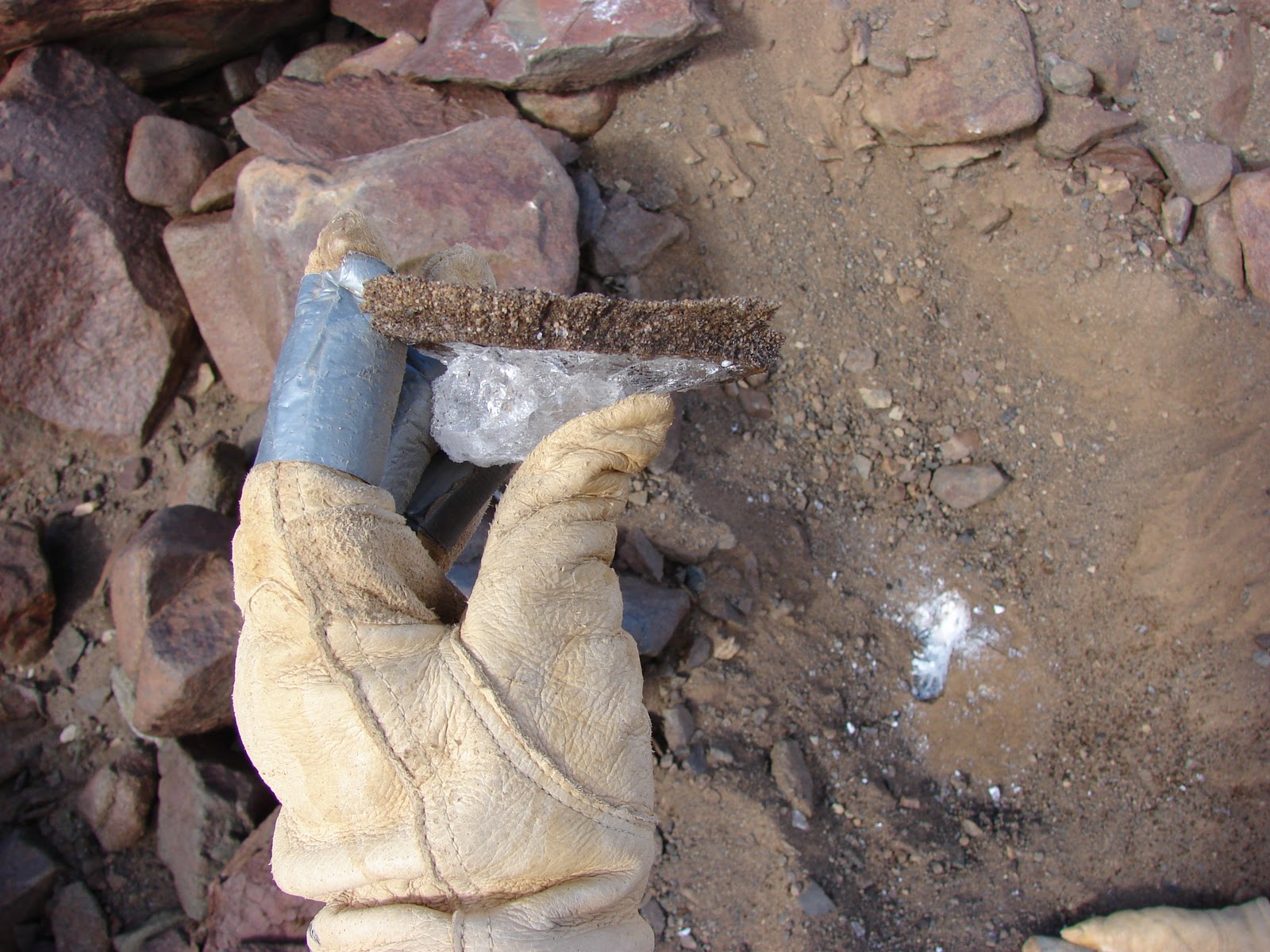
Some of the pits I dug were actually quite difficult because layers of ice cement sometimes overly the ice. The layer in the picture above is only a centimeter thick, but often times, you hit a layer that is several centimeters thick and nearly impossible to break through. When that happens, it's sometimes easiest to start digging elsewhere and hope you get luckier the next time.
Analyzing the ice chips is just one aspect of the research I do. I’m also interested in dating the air trapped in the ice cores, as well as analyzing the geochemical composition of the trapped air to reconstruct carbon dioxide concentrations. If you’d like to know a little more about what I do, check out my website - http://www.princeton.edu/~ayau/Audrey_M_Yau/Research.html.
The other researchers in the group have very different interests.
Jen Lamp is currently a PhD student at Boston University working with Dave Marchant. Her educational background is actually quite different from what her current degree is in. She completed a B.S. in Civil Engineering from University of Michigan and a M.S. in Mechanical Engineering from Virginia Tech. Her interests in Mullins Valley focus on rock fracture mechanics, specifically characterizing the mechanical breakdown of rocks by thermal stresses. Most of the field work she is doing includes conducting field experiments on temperature profiles of rocks, gathering data on the variety of boulder sizes with distance down valley, rock flake sampling, sampling transects of rock diversity along the valley, and collecting soil samples. Most of my time was spent helping Jen with her data collection.

What makes a rock go from this....
To that? Jen's research hopes to answer this question.

To help understand the rock breakdown process, we took several transects down valley, sampling the diversity of rocks along the transect. A transect is basically a path along which one collects data. You can collect any sort of data you choose, in our transects, we counted rocks of particular size and composition.

We also collected rock flake samples. The majority of the rocks overlying the glacier are Ferrar Dolerite, which exhibit a particular weathering pattern of flaking layers. Jen's interested in the flake composition and thickness with distance down valley.
Sean Mackay is also a PhD student at Boston University working with Dave Marchant. His educational background is also quite eclectic. He completed a B.S. in Physics and B.A. in Music from Southern Methodist University, and then completed a M.S. in Environmental Management at Oxford. His interests in Mullins Valley focus on geophysical analysis of the debris-covered glacier. He hopes to use Ground Penetrating Radar (GPR) to construct a higher-resolution image of the interior of the glacier. Using this data he hopes to understand the development of the glacier through the past 4+ million years. I spent a good deal of time helping Sean with his GPR measurements, which consisted of building transects (moving rocks out of the way of the GPR machine), and then re-filling in transects after GPR analysis was complete. Rocks had to be moved out of the way of the GPR to allow the radar penetrate with as little interference as possible.

woot woot! science! Sean's in the background messing around with the GPR.

Taking a break from moving rocks. Those rocks are big and heavy!
The field season is just a 1-3 month period of data collection. The real science happens back in the lab or in the office, where we analyze the samples we’ve collected, analyze the data we’ve gathered, and start putting the puzzle pieces together. Hopefully looking at the Mullins' story from a geochemist and geomorphologist’s perspective will help pull the exciting history behind Mullins Valley glacier together.
No comments:
Post a Comment